Derbyshire and Staffordshire
Manifold Valley – Ecton and Wetton – By Alan Garner
This walk takes in the stunning valley of the River Manifold, the delightful neighbour of the River Dove. The walk straddles the Derbyshire/Staffordshire border with a foot in each.
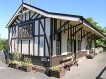
We start at Hulme End – a car park here with toilets and a lovely café – check for opening times. There is also, a small museum.
Hulme End was the terminus of the Leek and Manifold light railway which ran from Waterhouses and served this area for both agricultural and industrial purposes.
 ---
---.jpg)
The railway ran for 8 1⁄4 miles (13.28 km) down the valley of the River Hamps as far as Beeston Tor, before turning up the limestone gorge that the River Manifold had formed, through to Hulme End (The line had a large number of stations in a relatively short distance, and there were refreshment rooms at Thor's Cave and Beeston Tor. In all the line crossed the river Manifold dozens of times - including nine times in the short section between Sparowlee and Beeston Tor.
The railway served local communities for passenger services, and the Ecton Creamery for milk transport eventually going to London. It also served the copper mines at Ecton Hill. It only ran for 30 years, closing in 1934. The line was then converted to a cycle and walking route.
The Manifold Valley footpath and cycle way (now called the Manifold Way) was opened in July 1937 after the LMS handed over the track bed to Staffordshire County Council. It continues on to Waterhouses, via Hulme End, as a bridle path, and, being tarmacked throughout, is ideal for wheelchair users, prams, etc. For about 1 1⁄2 miles (2.4 km), near Wetton Mill, the route is shared with motor traffic where the C-road has been diverted, and this section includes Swainsley tunnel, built by Sir Thomas Wardle who, despite being a shareholder in the railway, did not want to see it crossing his land. Some spectacular scenery can be found along the eight-mile (13 km) route, including Thor's Cave, Wetton Hill and Beeston Tor. Many consider that this section bears comparison with the better-known Dovedale a few miles to the east. (The National Trust own several of these sites, as part of their South Peak Estate.)
The Old Light Railway Hotel at Hulme End is now called the Manifold Inn. There are campsites at Hulme End and Wetton Village.
At Ecton Hill a 4,000-year-old copper mine lies along the route; there is still evidence of the railway's loading platforms along the route of the old railway. A dairy once stood here, and one can still see where milk churns were once loaded onto the morning milk train. The Ecton dairy was famous for its Stilton cheese.
The old engine shed at Hulme End opened as a cafe called The Tea Junction in 2010.
Proceed along the track bed for 200 yards then take the footpath left across the fields – can be boggy in wet weather, eventually crossing the river to West side Mill – an attractive house conversion.
Turn right along the minor road and after 300 yards – a telephone box on your left, take the lane signed Back of Ecton. Ecton Hill is now on your right, here there are copper mines which we will see later in the walk.
Walk up the lane for about a mile and a quarter, and continue when you reach Lees Farm, where the lane starts to descend to the Manor House on your left. a lovely cottage– look out for the footpath sign on your left and over the stile. Here you have a choice – look to the valley slightly left and take the upwards rising path, over the stream - this may be dry in summer – and with Wetton Hill on your right climb upwards eventually reaching the outskirts of the hilltop village of Wetton., after passing a covered reservoir.
.jpg)
Here you will find an interesting church and a pub - the Royal Oak. Rest a while – then take the road out of Wetton signed Wetton Mill. After a hundred yards see a footpath sign in the left-hand side of the wall, take it across meadows. Eventually you reach a downwards path- can be muddy and slippery – through trees heading for the Manifold Valley.
A super addition here is a visit to Thor’s Cave – SIGNED OFF TO YOUR LEFT.
Thor's Cave (also known as Thor's House Cavern and Thyrsis's Cave) is a natural cavern, and the cave entrance, a symmetrical arch 7.5 metres wide and 10 metres high, is prominently visible from the valley bottom, around 80 metres (260 feet) below. Reached by an easy stepped path from the Manifold Way, the cave is a popular tourist spot, with views over the Manifold Valley. The second entrance is known as the "West Window", below which is a second cave, Thor's Fissure Cavern.
The origin of the name is uncertain, possibly from the word "tor". Links with the Norse god Thor and the Germanic paganism of the early Anglo-Saxons in general have been suggested, but evidence is lacking. Other hypotheses have included lost ancient dialectal terms, and obscure English saints.
On reaching the valley, take the railway path which criss crosses the river and in about 0.75 of a mile reach Wetton Mill on your right. Here there are good refreshments run by local people. Toilets too.
.jpg)
.jpg)
We leave the old rail line here and take the path out of the mill, left of the toilets and reach a lane- follow this quiet farm lane with the river now on your left. Look out for the limestone crags on your left - in a mile you meet the lane coming in from the left – join this – it’s a bit busier but still pretty deserted and you will enter the site of the loading area – onto rail wagons for the Ecton Creamery and also for the Ecton copper mines -Look out for mine entrances on your right here. And waste heaps which tend to be little populated by plants due to the toxicity of the soil extracted from the mines.
.jpg) ---
---.jpg)
Proceed along the lane- look out for the copper coloured spire to Ecton Church and perhaps divert for 10 minutes to look at the small hamlet of Ecton off to your right.
In 10minutes walking you switch over to the rail bed again – and walk back to Hulme End.
The walk is 9 miles mainly flat with just the ascent to Back of Ecton and Wetton and the descent into the Manifold Valley from Wetton.
Manifold Valley images
.jpg) ---
---.jpg) ---
---.jpg)