Mid Wales - Llandrindod Wells, the Radnorshire Hills and the Elan Valley
Llandrindod Wells, a Lake, a Dragon, and the Elan Valley Walk - By Alan Garner
Whether you just fancy a leisurely stroll or a challenging hike Elan has something for everyone. There is open access over most of the 70 square mile Estate, and there are over 80 miles of designated rights of way. There are many walks and trails with a good mixture of lengths to cater for all, including nature trails and scenic walks.
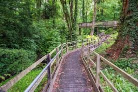
The Elan Valley Trail is a favourite with its surfaced paths which follow the route of the old Elan Valley Railway. It is for use by walkers, horse riders and cyclists and suitable for pushchairs and wheelchairs.
Terrain on the hills of the Estate can be challenging, varying between tussocks of purple moor-grass to deep patches of sphagnum moss, plus there are frequent sheep tracks which are easily mistaken for upland paths. Some navigational skills are essential, and Ordnance Survey maps and compasses are necessary for some of the longer routes.
Our walk
Starts in the centre of Llandrindod Wells- make your way to Rock Park to start with – a Victorian designed feature which has used all the local features to enhance its beauty.
Originally set out in the 1860s to cater for the flourishing spa trade, the Rock Park today provides twelve acres of mature woodland with plenty to see and do. You can discover the Chalybeate Spring and sample the waters.
Many of the Victorian Spa buildings remain including the original Pump Room. The Park includes three international standard bowling greens. The Spa buildings house the Rock Park Complementary Health Centre and the Rock Park Cafe.
Look out for the spring mentioned above then follow the path left towards the lake, passing under the Heart of Wales rail line.
Reach the lake – a haven for birds, swans, ducks and waterfowl.
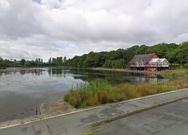
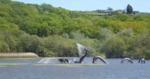
The 13-acre lake, an unexpected feature of the town with a magnificent dragon statue at its centre, is a perfect place for a stroll or cycle ride. Visitors enjoy the views of the lake and surrounding area and the nearby picnic area is popular in the summer and there is a Lakeside Café and Bistro that provides light refreshments and full meal services.
Llandrindod Lake was originally built as a boating lake towards the end of the last century when Llandrindod Wells was a prime Victorian tourist destination with thousands of visitors arriving each year to take advantage of the famous spa waters. The original boathouse can still be seen to the left of the lake, now converted into a private residence.
The lake is also popular with fishermen and has recently been drained, cleaned out, and new fish stocks introduced. There is an abundance of wildlife including ducks, geese and swans. The island in the middle of the lake provides an undisturbed habitat for birds, insects and other wildlife.
Walk round the lake on its west side passing the café- excellent food and drink here- and make your way round the far side and up the hill with the old Llandrindod Parish church coming into view.
.jpg)
Pass through the graveyard on a marked path – and take a right to reach a stile and immediately turn left onto a broad track. Follow this for half a mile then see a footpath going left – slightly uphill to a stile- you pass over old lead mine workings – now just like giant mole hills. - and make for the field boundary in the corner to your left. A difficult stile- proceed slightly downhill – can have much bracken after June- but look for a fingerpost – low down – on your left- don’t go to the bottom of the slope – the post is halfway down.
Here you turn left. Now carry on through the bracken and low trees, see a stile in a wall and over it.
You reach a lane- take a left onto it, and with super views – walk for a mile and a half along this quiet lane., passing Tygwyn.
When the lane meets a road, turn left for about 1000 yards, until you meet another road, turn right here.
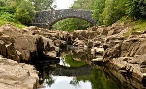
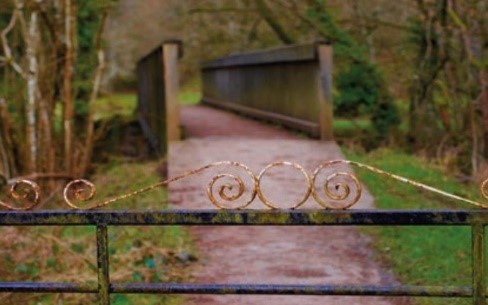
follow this road sharply down hill- and reach Lower Llanoly – a small settlement of three houses. When the road turns right and uphill, see a footpath on the left. Take this and wander slightly downhill, through grassy meadows and eventually a small wood. Reach another road. Left then right over the footbridge – called Shaky Bridge. In front of you is the ancient church of St Michaels – worth a diversion and a good picnic spot.
Reverse back to Shaky Bridge, and bear right on the road for 200 yards, then take the bridle path left – about 600 yards and meet the road- the one you passed down to get to Lower Llanoly.
This time take a right- uphill until you see the footpath sign on the right.
This leads to a trig point, past it and head into the right-hand corner of the field- another path from the right joins it.
Take a left onto this path- there are many paths now leading to Llandrindod, we suggest you take the left one through the woods and finish by the lake. From here – either go through the Powys County Council grounds or take the lakeside path back into the town.
6 miles Good paths 140 metres of ascent/descent.