Shropshire’s Bluebells, hidden valleys and Jack Mytton
A Walk in the Bluebells – By Alan Garner
This is a walk that takes in the superb Shropshire Hills countryside without climbing any of its peaks.
We start at the east side of Church Stretton rail station, proceed over the A49 trunk road, and at Watling street, beside the Methodist church and opposite Sandford Court turn left. Continue over the Much Wenlock road along Watling street for 500 metres then take the field stile just before the entrance to the farm.
Proceed up to the stile in the left corner of the field and walk into Helmeth wood – spring bluebells are spectacular. The path rises slightly – keep to the right-hand side path – don’t turn up to the hill summit, after 5 minutes – take the stile into the field and then another into Gaerstone Lane farm. Go downhill here to the Much Wenlock road again.
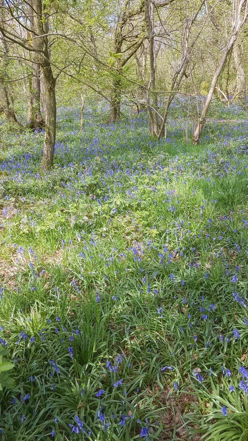
An ancient woodland adorning Helmeth Hill just half a mile east of Church Stretton. Visitors can follow a circular path to explore a wealth of ancient woodland species including small-leaved lime and toothwort yellow archangel and wood sorrel. It is managed by the Woodland Trust.
Turn left and take the stile into the field, then follow the clear path heading across to the right. Through fields the path eventually runs alongside a small stream. Enter Hope Bowdler village and turn right for 50 metres before taking the lane left for St Andrews church. Past the church and see a footpath sign tucked away on the right, take this into a narrow path between fields to the stream at the bottom of the slope, cross footbridge and take the right hand path up Yelds Bank, a short steep rise to a stile at the top.
.jpg)
Hope Bowdler is a small village and civil parish in Shropshire, England.
It is situated on the B4371, 1.5 miles (2.4 km) east of the market town of Church Stretton. The village is at 222 metres (728 ft) above sea level.
There is a parish church in the village, dedicated to St Andrew. The parish is rural and hilly, and contains the hamlets of Ragdon and Chelmick.
From here keep to the right of the field to a stile then walk sharply down into the Soudley Valley, there are pools here, but well wooded areas can completely obscure the view.
Right along byway for 70 metres, then left onto the road, proceed with the pools on your left for 500 metres, and at the phone box – one of just a few left- take the upward road right signed Marshbrooks/ Acton Scott. After 400 metres slightly uphill, see a bridle path sign on the right, take this – it is the Jack Mytton Way.
The Jack Mytton Way is a long distance footpath and bridleway for horse riders, hillwalkers and mountain bikers in mid and south Shropshire, England. It typically takes a week to ride on horseback.
For much of its length it passes through the Shropshire Hills AONB and includes parts of Wenlock Edge. It passes over the Clee Hills, and through the towns of Cleobury Mortimer, Church Stretton, Clun and Much Wenlock, passing close to Bridgnorth, Broseley and Highley. The south-west end is at Llanfair Waterdine. East of Roman Bank, it forms a loop.
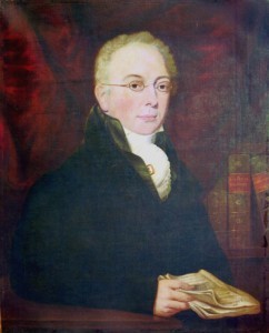
It is named after Jack Mytton (1796–1834) a Shropshire landowner, MP, horseman, foxhunter, gambler and Regency rake. He was also known as Mad Jack.
Jack Mytton
A new MP who quits the House of Commons after half an hour never to return can’t be all bad. The dull speeches which drove Shropshire’s Jack Mytton from Westminster ensured he now had time to turn his life into an undying legend.
Born only eight years later than Lord Byron, the original “mad, bad, …” Mytton merited the nickname Mad Jack. To test the jumping ability of a horse he was trying, he galloped his carriage at a closed tollgate. The lead horse leaped over, broke the traces and destroyed the carriage. Jack and his companion were thrown out.
Disguised as a highwayman, he held up two gentlemen who were riding over to dine with him. Once he jumped his horse over the table laid for dinner.
He inherited good looks, charm and a fortune. He possessed courage and unusual skill with horses. He was a talented sportsman with gun and horse and a great lover of the countryside. Soon all was dissipated. “There he stood before me, a round-shouldered decrepit, tottering old-young man, bloated by drink, – there was a body as well as a mind in ruins … a wreck over whom all the storms of life seemed to be engendered in one dark cloud” wrote his biographer, a horse-dealer and sporting journalist.
An ulcerated leg turned gangrenous and he died in a debtor’s prison aged 38. Crowds lined the roads along the fifteen-mile funeral route, the church bells tolled, and every shop was closed.
Before taking this path gaze over the fields to your left-over Wenlock Edge and distant Clee Hills, super views.
.JPG)
The path now is closed in by trees, a farm initially on your left, the path is mainly level here above the Chelmick Valley on your left. Proceed for 700 metres then meet a country road where you turn left.
This road takes you after just under a mile to Chelmick hamlet -again magnificent views over the Wenlock Edge and surrounding countryside – look out for Flounders folly on the right of the ridge in front of your view.
Flounders Folly
Although Flounders’ Folly is a familiar Shropshire landmark, its story is not well known. The Folly is a stone tower, 16 feet square and 80 feet high, standing on Callow Hill, near Craven Arms in South Shropshire. It is a Grade II listed building and a much-loved local landmark.
Benjamin Flounders, a Yorkshireman from a Quaker background inherited the estate at Culmington in South Shropshire from his uncle, Gideon Bickerdike and built the tower with local stone and local labour in 1838. The site marks the point at which three parishes and four major estates meet.
Curiously, Benjamin Flounders never had a house on the Culmington estate and generally chose to stay at the Angel Inn (now accommodation and shops) in Broad Street, Ludlow on his twice-yearly visits to Shropshire.
Why the Folly was built?
There are various stories as to his reasons for building the tower. These vary from a theory that he wanted to create work for the unemployed to the rather fanciful idea that he hoped to be able to watch his ships on the Mersey and the Bristol Channel! It was however the year of his 70th birthday and he may have built it just to celebrate that and to leave his mark on the Shropshire landscape.
.jpg)
The original drawings for it by a Ludlow architect still survive in the North Yorkshire Record Office at Northallerton. It was built from local stone, 80 feet high and16 feet square, with walls two feet thick and small slits of windows. It originally had a castellated top around a viewing platform which had a flagpole. This was reached by a wooden staircase that went from side to side. Apparently until well into the 20th century there was a cupboard on the top which housed a picnic box with crockery and cutlery, which could be used by those who completed the climb successfully.
The folly remained in quite good condition for the first 100 years but began to suffer damage around the time of World War Two. The platform and the staircase gradually became unsound and in the late 1980s the whole of the castellated top became unsafe. It is believed that for safety reasons the district council pushed the large stones to the ground where they lay for the next 15 years. Flounders Folly was then fenced off by the local authority as unsafe. It looked a sad sight. Nevertheless, the Folly has been an enduring focal point for local people and visitors from further afield.
How the Folly was restored?
The Flounders Folly Trust was set up in 2000 by a small group of people interested in saving and restoring the folly. They acquired the freehold of the tower and the plot of land it stands on for £1 in 2001 and set about raising funds to restore it.
In the early part of the new millennium, Mark Newall of Trust-appointed architects Baart Harries Newall of Shrewsbury drew up plans for the tower’s restoration.
The main change to the original design was the staircase. The original wooden stair was replaced with today’s highly durable metal stair. Towards the top this becomes a spiral stair which leads the visitor to the platform at the top through a hexagonal glass dome. Visitors can now walk all round the platform and enjoy the view in all four directions from the corners of the tower.
Restoration work began in the spring of 2004, made possible by a large grant from the Heritage Lottery Fund in the West Midlands, and with funding from the Local Heritage Initiative, the Esmée Fairburn Foundation, the Millichope Trust and many other generous donations from organizations and individuals. From the hamlet- we walk for a mile and a quarter along a quiet country road with Ragleth Hill in front of you and eventually the craggy rocks of Caer Carodoc and the grassy Hope Bowdler Hill on your right, Gaze over the farm gates at the beauty here, take those snaps!
Once you reach the Hope Bowdler road – called Bull Lane – by the gate just after the lane on the right, take a stile/gate and go diagonally across the field to the opposite corner and another gate/stile. This brings you out at the path leading to Church Stretton, proceed downhill through trees with a stream on your left, eventually leading to Snatchfields farm, long abandoned but interesting vestiges of farming life. As you descend – the vista of the Long Mynd is in front of you, with lots deep valleys and lofty peaks.
You enter a housing estate, follow the path signs slightly left and reach a short stretch of path between houses to reach the lane with Sandford Court in front of you.
You are now back at your start point.
Trains to Church Stretton from the North West/Birmingham/South Wales are regular and run by Transport for Wales.
Church Stretton several cafes and pubs for refreshments at the end of your walk – proceed over the rail bridge and up Sandford Avenue to High street for a choice.
6.1 miles – highest 311 metres start at 185 metres
3 hours