Wales - Cwmyoy, Abergavenny
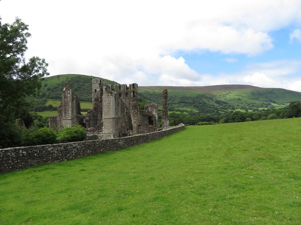
Revenge, The Priory and the Crooked Church - By Clif Strover
This 13 mile walk strenuous includes a climb to 2000ft. It features some steep descents and climbs. It also requires map reading skills on Hatterall Hill.
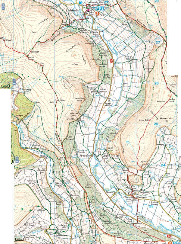
Start at the Queen’s Head Cwmyoy (NP7 7NE) on the road to Llanthony Priory from Llanvihangel Crucorney or in the woods above. There is a car park just after the pub alternatively turn left up the single-track road just after the pub. Drive steeply uphill there is a forestry track with plenty of parking spaces about 1/3 mile of a mile up this road.
The instructions start from the forestry car parking space. Return to the tarmacked single-track road and turn right up the track. Admire the views across to the Skirrid as you climb up the tarmacked road. At the end of the tarmacked section go through the gate (1) and pass under the watch full eye of Twyn-y-Gaer Hill fort. It is worth visiting the fort and admiring the deep twin defence ditches. Follow the track keeping the wall on your right. The track narrows and you pass through a gate. There is a wood on the right behind a low wall follow this keeping it to your right. As the wall turns downhill (2) keep straight ahead along the track past the Revenge Stone where it is said a Norman Knight was killed by Welsh Guerrilla Fighters. You join the Beacon’s Way Long Distance Path here. There are fine views across the Vale of Ewyas to Hatterall Hill.
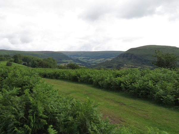
After lunch pass through the gate into the woods and follow the broad track. In the woods the track splits, one branch turns hard left but we turn right crossing the stream (6) and follow the track to the edge of the woods. Climb over the stile and continue to climb through the fields, it is a steep climb but it is ok stop, look back and admire the views across the Vale of Ewyas to Bal Mawr. Ignore the stile on the right and keep climbing. Cross over another stile on to Hatterall Hill, there is an information board as you climb over the final stile of the climb. After reading the board turn right and follow the track which climbs gradually up Hatterall Hill, staying on the Beacons Way. Keep climbing to the top of the ridge where the Beacons Way and Offa’s Dyke Paths converge. Follow a broad path along the ridge. Hatterall Hill is very popular with paragliders and you will probably have noted many of them flying off the hill when we walked the other ridge to Bal Mawr. Looking ahead you will notice a ridge bearing to the right, this is the ridge we will need to follow. After three quarters of a mile you will pass the remains of a quarry building on the left (7), the path turns sharply left and crosses a steam. To find this point you will need to have the map or GPS to hand for this point is easily passed.

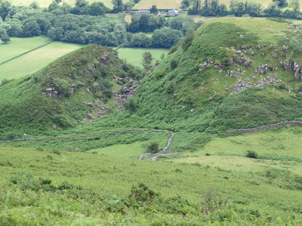
There is a path marked leaving to the right, it is not clear so you will have to cut across the hill, making your own path. After a few hundred yards you will come across some tyre tracks heading along this right-hand ridge follow these. As you climb up a slight rise and you will clearly see the Skirrid on your left and the Sugar Loaf straight ahead, keep walking towards the Sugar Loaf along the ridge. If the Skirrid is straight ahead and the Sugar Loaf is to your right you are on the wrong ridge and will need to retrace your steps. Keep past a shooting butt and follow the path along the ridge, with views of the Sugar Loaf ahead and the Skirrid on the left. At the end of the ridge stop and take a look. You will see another small hill below you and before that a track between two walls. This is where we will pass.
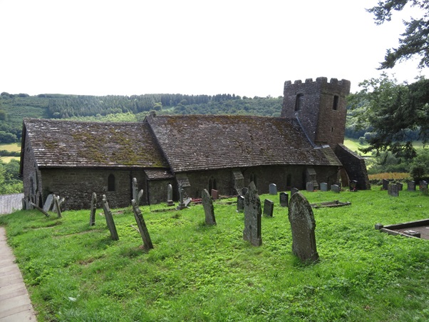
Follow the path down off the ridge, descending, at times, very steeply down. The path veers to the left, keep on and descend further. You will come across the remains of a building; the map or GPS is again useful here. Pass close to the building keeping it on your left. At the bottom corner of the building, (8), look hard to your right and you will see a path in the head high bracken. This is the path you need, do not turn to the left at the end of the building or keep downhill but follow this path through the bracken. You will soon come a wall at the bottom of the hill, turn right and follow it to the track between the walls. Pass down this track, at the bottom of this track on the right is a stile, cross over this, do not continue to the end of the tack or climb over the stile to the bottom of the hill. Bear right across the field to an over grown road. Follow this road downwards and through a gate where the road becomes more defined. The track passes a house on the left. Where the road turns left there is track straight head, follow this and continue down. The track. Come out opposite the crooked church at Cwmyoy. The church is described as “the most crooked church in Britain”, the writer Simon Jenkins describing the church as “visitors might be on the deck of a galleon in a storm, with the chancel about to slide overboard". Inside the church there is an impressive Middle Age cross which is worth seeing. The inside of the church is as crooked as the outside.
Walk around the outside of the church and pass through the metal wicket gate on the downhill side of the church, near the tower. Pass along the track to the road at the bottom. At the bottom of the lane on the house opposite there is a fine set of mounting steps, provided to enable people to mount a horse easily. Turn left and walk along the road past Cwmyoy Farm. Not long after the farm there is a stile on the right. Cross this walk down the field keeping the hedge on your right and cross a bridge. After the footbridge bear left then up past a house on your left. Over the stile and cross the road to the farm track. Walk up the farm track, turning sharp left at Coed Farm. At the top end of the farm house there is green track diagonally to the left. Follow this and climb up over a stile into the woods. Continue up this path until you come across a wide forestry path. Turn left on this and return to the forestry car park.